This course is designed to provide an introduction to key terms, definitions and concepts in Forensic and Expert Social Anthropology.
Course Tutor: Dr James Rose
8 x 1-hour classes
AUD$450 / GBP£245
Starting date: TBC
Dates are currently flexible. Please email education@therai.org.uk with any questions.
This course is ideally suited to students of social anthropology, early- and mid-career practicing social anthropologists, especially those currently or planning to work in legal-administrative settings, as well as interested members of the public.
If you are already an enrolled student, you can access our Moodle platform here:
Tutor biography
Dr James Rose is a forensic and expert social anthropologist specialising in culturally-based land claims, cultural heritage protection, data governance and geographic information systems. His methodological focus includes network-based population dynamics and social and kinship network analysis. James holds two decades’ experience working with Australian state, territory and federal government agencies and departments, Commonwealth institutes, industry regulators, health service providers, universities, community-controlled organisations, and the private sector, and is a Senior Research Fellow with the Melbourne School of Population and Global Health.
University of Melbourne: https://findanexpert.unimelb.edu.au/profile/843112-james-rose
ORCID: https://orcid.org/0000-0003-4983-1393
Private consulting website: https://www.relational.net.au
Course objective & structure
Upon completion, students will have a working knowledge of forensic and expert social anthropological terms, definitions and concepts relevant to culturally based land claims, including elementary theoretical principles and methodological techniques. Students will develop an understanding of the relationship between national-level legal-administrative land claim regimes and international conventions, based on relevant case studies.
The course will be delivered synchronously in a virtual format over 8 x 1-hour classes. Each class will be comprised of a seminar oriented towards recommended readings and case studies, followed by class discussion.
Classes are designed to introduce students to contemporary best-practice in the subject area by orienting them towards case studies based on the tutor’s professional experience and leading relevant literature. The discussion component of each class is intended to allow students to familiarise themselves via a semi-structured Q&A format with the tutor.
Summary of seminar topics
- Class 1: Identifying communities of culturally-defined land owners
- Class 2: Identifying appropriate idea systems for land tenure modelling
- Class 3: Linking culturally-defined communities to areas of land
- Class 4: Modelling and analysing culturally-defined communities
- Class 5: Modelling and analysing land areas
- Class 6: Integrating models of community and models of land
- Class 7: Participatory Mapping in Land Claims
- Class 8: International Examples of National-Level Land Claim Processes
Class 1: Identifying communities of culturally-defined land owners
This class introduces social anthropological definitions of culturally-based land tenure, using a 3-part model comprising: a) autochthonous models of tenure; b) autochthonous mechanisms of tenure transmission, and; c) autochthonous mechanisms for realising tenure. The class will focus on a) models of tenure arising from systems of ideas spanning kinship, language, religion and economy; b) mechanisms of transmission including heredity and exchange, and; c) mechanisms for the realisation of tenure, including ownership, custodianship and stewardship.
Questions
- What are the key features of idea systems by which communities of people define their claims to land?
- What are the key features of the mechanisms by which claims to land are transmitted?
- What are the key features of the mechanisms by which claims to land are realised?
- Why is isomorphism between idea systems a critical factor in modelling land tenure?
Class 2: Identifying appropriate idea systems for land tenure modelling
Legal-administrative processes vary significantly with regard to statutory and common law requirements for demonstrating culturally-based land tenure. This means that FESA practitioners must select appropriate idea systems on which to model land tenure, according to a range of contextual factors. This class introduces principles for identifying the most appropriate idea systems on which to model land tenure, using the three-part model introduced in Class 1. The class will focus particularly on the interdependence between claims to ownership, custodianship and stewardship of land.
Questions
- What are some of the key international examples of culturally-based land claim regimes?
- What is the key difference between statutory and common law requirements for FESA input, with regard to culturally-based claims to land?
- What are some of the historical factors that should be considered when identifying appropriate parameters for modelling culturally-based land tenure?
- How are ownership, custodianship, and stewardship affected by historical factors, and how does this influence the identification of appropriate bases for modelling tenure
Class 3: Linking culturally-defined communities to areas of land
Using the three-part model introduced in Class 1, this class describes methods for identifying areas of land over which a given autochthonous community asserts tenure according to culturally-specific idea systems.
Questions
- formal models of land tenure?
- What types of information need to be collected and what types of data need to be processed from this information in order to build formal models of land tenure?
- What is the minimum requirement for such formal models to be considered reasonably probative?
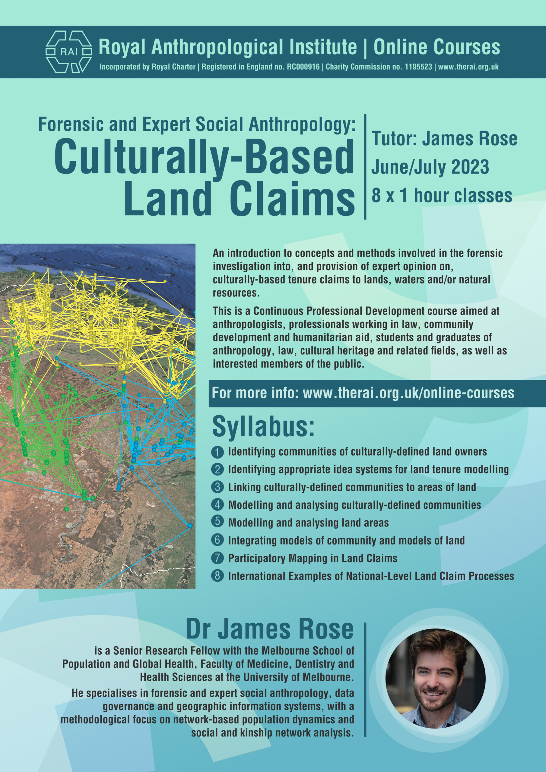
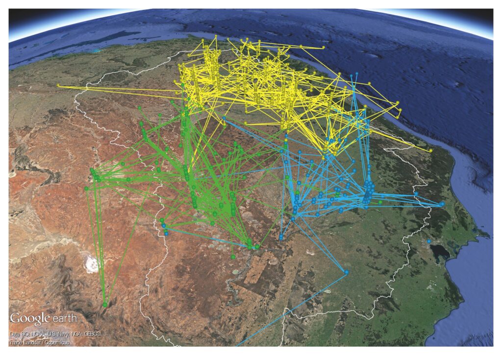
Class 4: Modelling and analysing culturally-defined communities
This class introduces technical methods for modelling communities of culturally-defined land tenure holders, including matrices and networks, where land tenure comprises an extensible attribute of these models. The class introduces methods for analysing these models using entry-level software.
Questions
- ow can matrices be used to model data on culturally-based land tenure?
- How are network models built from matrices?
- How can network theory be used to model communities of culturally-defined land tenure holders?
- What are the relative merits of matrix and network models for demonstrating culturally-based land tenure?
Class 5: Modelling and analysing land areas
This class introduces technical methods for modelling areas of land, including elementary geospatial models, and methods for analysing these models using entry-level software.
Questions
- What are the three key elementary objects used in geographic information systems (GIS) and how are they used to model geography?
- What are the key features of all GIS software?
- What are some examples of industry standard GIS software and what are some of the basic differences between them?
- What are the basic functions of Global Positioning Systems (GPS) in fieldwork associated with mapping land claim areas?
Class 6: Integrating models of community and models of land
This class describes theories and methods for linking models of communities and models of land into integrated systemic models of tenure, mechanisms of transmission, and mechanisms for the realisation of tenure. The class introduces methods for visualising these integrated models using entry-level software.
Questions
- What are the contrasts between conventional territorial mapping and FESA mapping in the context of land claims?
- What opportunities are conferred by existing GIS and GPS technologies for FESA mapping?
- What are two key methods for integrating matrix and network models into GIS models?
- What are the two key corollary methods for detecting association between culturally-based tenure-holding communities and specific areas of land?
- What are the relative merits of these two integrated models and attendant corollary methods for detecting association?
Class 7: Participatory Mapping in Land Claims
This class overviews approaches to participatory mapping in legal-administrative settings, and reviews relevant international examples of participatory mapping as a form of forensic investigation.
Questions
- What are the merits of participatory mapping as a FESA investigative technique?
- What are some of the risks that participatory mapping can introduce and how can these risks be managed?
- What are the distinct data collection methods involved in local and remote participatory mapping?
Class 8: International Examples of National-Level Land Claim Processes
This class revisits variations between statutory and common law land claim regimes introduced in Class 2, and introduces specific international examples of each where FESA practitioners play a role.
Questions
- What are the key differences between statutory and common law frameworks for culturally-based land claims, from the perspective of potential FESA involvement?
- How do historical factors that vary within and between statutory and common law jurisdictions affect the role of FESA practitioners, and the scope of their involvement?
- What are some of the potential technological opportunities and constraints that FESA practitioners might consider in assessing the scope of their involvement in a culturally-based land claim?